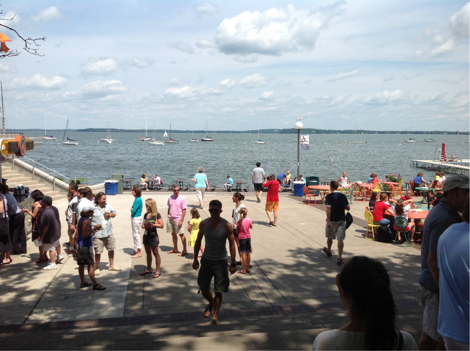
当前位置: 首页 >目的地 >北美洲 >美国 >威斯康星 >high bridge trail state park

high bridge trail state park

景区评级:4级
  • 景点介绍
  • high bridge trail state park
  • 景点印象
    • 2OBXN 图标 图标 图标 图标 图标

      Don't rely on the goggle address it will take you to the farmhouse they use as a office. The parking lot closest to the bridge is on River Rd off of Main St in Farmington VA. It's a mile to the bridge. There are two additional parking areas and one of them is for the horse trailers. I am 5' 9" and I had trouble taking pictures over the railing they have installed. I know that they don't want people to fall, but how high does it need to be, good luck if your shorter. It would be great to have a trail that you could take to go under the bridge.
    • 650bryanb 图标 图标 图标 图标 图标

      Just a mile out of Farmville heading towards the Big Bridge is an open gate with a little sign pointing the way to two Single Track Loops. The Blue blazed Early Loop and the Black Diamond Red Blazed Burnside Technical Loop. Being an experienced Mt Biker I chose the Red loop first and was pleasantly surprised. Fast Flowy and Fun! Lots of little trick spots, plenty of aerobic workout paced between twisted technical berm runs and fast tight turns. The 2.8 mile trail seemed more like 5. A whirlwind of drop-thrus and switch backs that will definitely test your technical skills.The Red Loop puts you right back at it's start and just a few yards from the Blue loop. So, I went right into Blue. After doing the technical loop I was ready for anything and in full on hammer mode. They Early loop didn't disappoint. Much easier and not as tight it had all the speed and flow you could ask for. A few spots that put you right on the edge where good skills were the only way to get thru at speeds.After a cruise over the bridge and pushing to the end of the trail I couldn't wait to get back for another go on the Single Track. Second time thru I didn't have to be so cautious and hit better lines. What a blast!
    • DAB821 图标 图标 图标 图标 图标

      The section where we started had limited (nearly full up on weekend) parking and no restroom facilities. Enjoyed hiking across historic bridge with my dog. Popular area for biking also. Most bikers respectful...some kids on bikes a bit out of control. Seem to remember the full trail being in excess of 20 miles. All relatively flat, handicapped accessable rail trail.
    • jeannettey_12 图标 图标 图标 图标 图标

      this bridge is so wonderful, would be GREAT place to watch the sunset or bring a picnic and enjoy the vew must be gorgeous in the autumn colors, brought a friend from out of town and loved it; we drove down from Midlothian.........worth the drive; the closest entrance to bridge is right in Farmville, we got lost trying to find other ways on to the bridge, most are 3 or 4 mile walk or bikeride so if you want just 1 mile or less to bridge go into Farmville.........lovely views
    • 97derekt 图标 图标 图标 图标 图标

      Very pleasant hike - beautiful quaint area. it's was a straight out and straight back hike for us from Farmville, but definitely worth doing - we'll do it again.
    • JeanRatedYou 图标 图标 图标 图标 图标

      The view is amazing! If you park on River Road there is a parking fee of only $3.00 and from there it is about a three quarters of a mile walk on a flat gravel road before you reach the bridge. The bridge is about a quarter of a mile long. You may also ride your bike down the trail. The bridge is in great condition and it's a day trip you won't soon forget. The bridge is in Farmville and is not 5 miles from Farmville like another reviewer wrote. If you park in the parking area on Rt. 460 instead of River Road the walk is longer at about 2.5 miles. I have been to this state park four times and I will go again the next time I'm in town.
    • debbiew544 图标 图标 图标 图标 图标

      We went to Farmville and hopped on the trail. The high bridge was about 5 miles from Farmville. That was probably the best part of the trail. Not very scenic otherwise, just lots of trees and the gravel railbed. We rode 15.5 ,miles to the end of the trail then back again. We thought it would be an easy ride but it took us longer than expected and it was harder due to it being all gravel. Paved road would have been nicer to ride on. It would be nice to go back when the leaves change and walk on the bridge to look out into the valley with all the color. I wouldn't bike it again.
    • tuckster2010 图标 图标 图标 图标 图标

      My son and I got on the trail in Farmville and walked to the bridge. That’s about eight miles round trip. There are other access points that will get you closer to the bridge. The trail is an old railroad and it is in great shape. The view from the bridge is awesome. It is a good way to exercise, get a history lesson and see beautiful scenery.
    • jdowner76 图标 图标 图标 图标 图标

      Pros: great view from the bridge, flat and easy for walkers and bikers alike. Also the port-a-potties were the cleanest I had ever seen. There are a couple picnic tables near the River Road parking lot if you bring lunch with you. It's a nice distance if you start at the River Road lot, go to the end of the bridge and then turn back. That's about 3 miles.Cons: No trash cans anywhere. Not much shade. Be sure to wear a hat and/or bring sunscreen and be prepared to be blasted by the sun. It's kind of boring. It's just a straight walk for as long as you care to go and then you have to turn around and go back. I preferred the loop around Beaver Lake at Pocahontas State Park due to the variance in terrain and the fact that you didn't have to retrace your steps. There is a fee of $3 ($4 on the weekend) to park at River Road and there's no way to make change. The ranger arrived sometime after we did (around 10am on a Saturday) and he did compare envelope IDs to the tags hanging in cars to ensure everyone had paid.Bring friends, as we did, and enjoy being outside with people you enjoy spending time with and it'll be all good.
    • thymegrower 图标 图标 图标 图标 图标

      Flat, flat, flat, making it an easy walk for everyone. We parked at River Road (there is a small charge and a ranger went through while we were there making sure everyone complied with their self pay system). We walked the three mile round trip to the end of the 125 foot high former railroad bridge. We were so lucky to have an enthusiastic park ranger give us a free tour. In October, we were glad we brought jackets, although it was warm on the path, it was a bit chilly breeze on the actual bridge. Bikers and Hikers mix well since the pathways are wide enough for both. Suitable for young and old alike. The friendly park ranger brought an elderly couple with walking issues up to the edge of the bridge (I assume you would make arrangements ahead of time).
    Copyright © 2021 All Rights Reserved 版权所有 八度伴旅网